A four-level residence at Kengalla, Kandy District, designed around the land’s own contours – and why a contour plan is not optional in the hill country the way it often is in Colombo or Jaffna.
By Eng. Rajmohan Rajragavan, Director · Reviewed by Archt. Ruwanmali Pathiraja, Chartered Architect
Published: 10 August 2026 | Last reviewed: 10 August 2026 | Reading time: 15 minutes
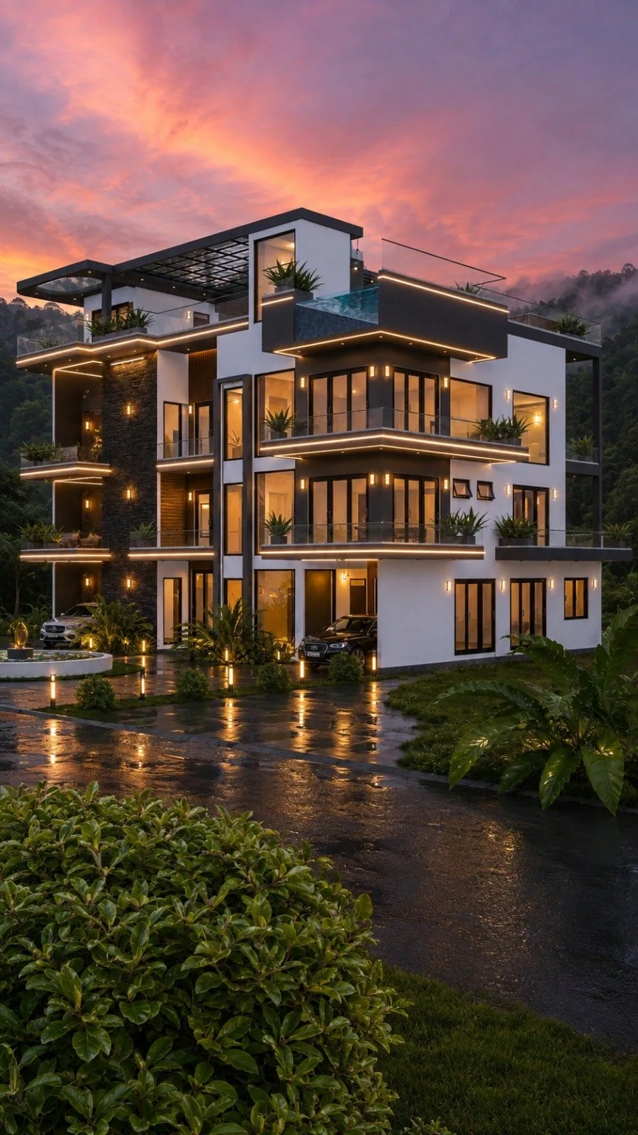
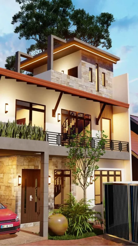
Figure 1. The completed design seen from the approach. Four occupied levels plus a roof terrace, stepped into a Kandy hillside with the forested valley beyond.
The project at a glance
| Recorded on the drawings | Value |
|---|---|
| Location | Kengalla Village, Udagampaha Korale of Pata Dumbara, Kandy District, Central Province |
| Site area | 27,221.51 sq ft (approximately 100 perches) |
| Basement floor | 696.50 sq ft |
| Ground floor | 2,509.28 sq ft |
| First floor | 2,426.42 sq ft |
| Second floor | 2,322.56 sq ft |
| Roof terrace | 2,322.56 sq ft |
| Total plan area | 10,277.32 sq ft |
| Ground floor site coverage | About 9.2% of the plot |
| Sleeping rooms | Eight, including two staff bedrooms at basement level |
| Bathrooms | Seven |
| Vertical circulation | Curved main stair, secondary stair, and a lift serving four levels |
| Survey plan | Plan No. 2266, Extract of Lot 2, prepared 5 March 2019, resurveyed from Plan No. 3390A of 2 August 2005 |
| Contour plan | Plan No. 4152, scale 1:500, contour interval 1 metre, assumed datum 100 m at the road |
| Drawing set | SEC-1814, layout revision R8, dated 5 August 2026, scale 3/16" = 1′-0" |
One detail in that table is worth pausing on. The layout is at revision R8 – the eighth iteration of the plan. On a site this complex, arriving at the right answer is not a single act of drawing; it is a process of testing floor levels against ground levels until the building and the land agree.
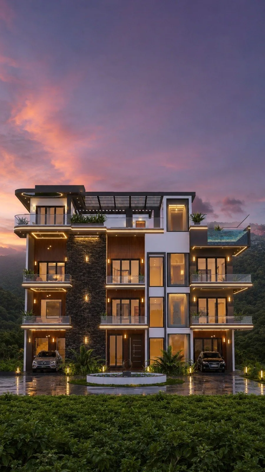
Figure 2. The aerial view shows what the section is doing: an upper pool and jacuzzi terrace, a pergola-covered bar level, and the mass stepping down and back into the hill.
DOCUMENT 01
The survey plan: what it tells you, and what it cannot
Every project starts here. The survey plan for this land is an extract of Lot 2 in Plan No. 2266, prepared by a Licensed Surveyor and Leveller in March 2019, itself a resurvey of a lot in a 2005 plan of an estate land. It carries a Pradeshiya Sabha approval reference and stamp from July 2019, which is what makes it usable for a building application rather than merely informative.
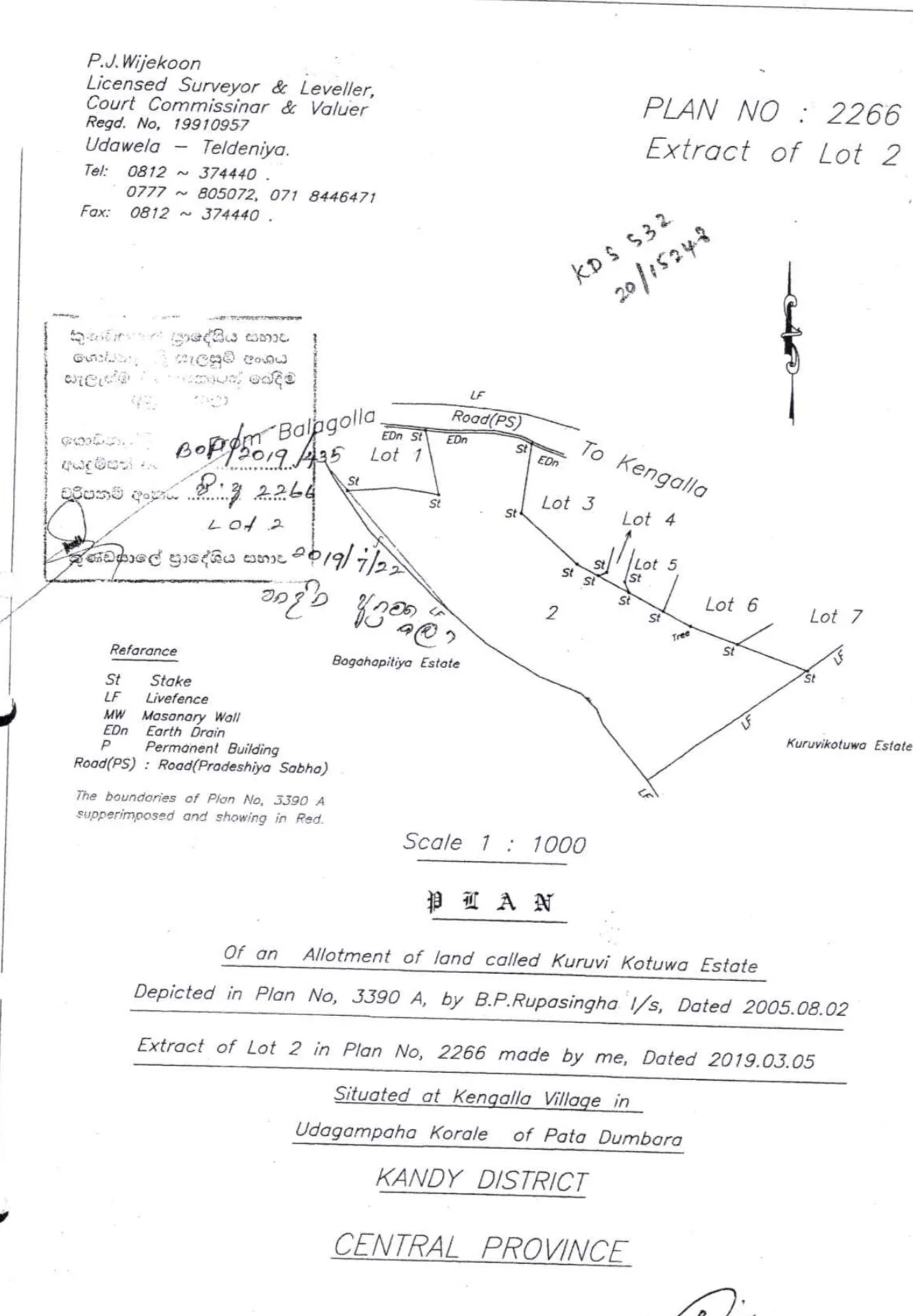
Figure 3. The approved survey plan. Note the road marked as a Pradeshiya Sabha road, the earth drain symbols along the frontage, the live fences forming boundaries, and the adjoining lots and estate lands.
Read carefully, this plan is already telling you three things about the site that will shape the design:
The access is a Pradeshiya Sabha road, and the frontage carries earth drain symbols. There is existing surface drainage along the road that the design must respect and connect to, not build over.
Several boundaries are live fences rather than walls. Live fences grow, are cut back and are re-planted; they are a poor long-term record of where a boundary actually is. On sloping land this matters more, because a boundary line on a plan and a hedge on a slope can differ by a surprising margin.
The plan notes that the boundaries of the earlier 2005 plan are superimposed in red. That superimposition is the surveyor reconciling two records of the same land – exactly the kind of check a bank and a local authority will look for.
But here is what the survey plan does not tell you: whether the land is flat. It shows extent, shape, boundaries and access in plan. It does not show the third dimension. On a plot at Kengalla, that omission is the whole problem.
DOCUMENT 02
The contour plan: the drawing Kandy projects cannot skip
A contour plan is a separate survey, usually by a separate instrument and often a separate visit. It records the shape of the ground surface as a set of lines joining points of equal height, plus individual spot levels at features and boundary points.
For this site the contour plan is Plan No. 4152, at 1:500, with a contour interval of 1 metre and levels referred to an assumed datum of 100 metres taken at the road.
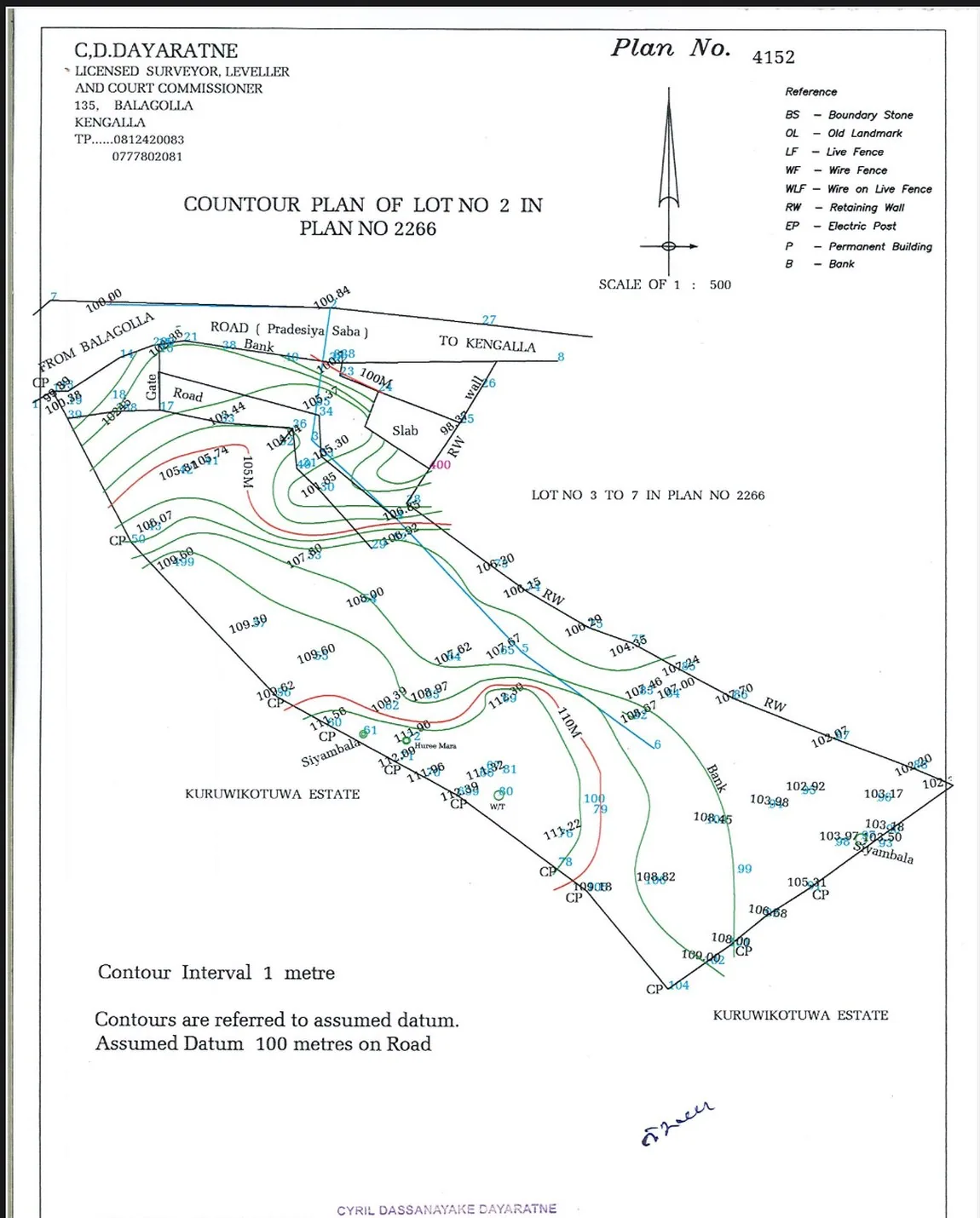
Figure 4. The contour plan for the same lot: 1 metre contours, spot levels at boundary points and features, the 100 m, 105 m and 110 m contours highlighted, existing retaining walls, banks and a gate recorded, and a drainage line crossing the plot.
How to read it
The assumed datum is the key to the whole drawing. The surveyor has fixed the road as 100 metres, not because the road is 100 metres above sea level, but because a local datum makes every other number on the plan immediately meaningful as a height above or below the access point.
Against that datum, the spot levels on this plan run from roughly 98 metres near the lower boundary to roughly 113 metres at the upper part of the plot – about 15 metres of total fall across the land. That is the height of a four-storey building, contained inside a single plot of about 100 perches.
The plan also records what is already on the ground: existing retaining walls, banks, a slab, a wall, a gate, an internal road, electric posts, boundary markers, and named trees including siyambala. And critically, drawn in a different colour and running diagonally across the plot, a drainage line – the path water already takes through this land.
Why Colombo and Jaffna often get away without one
This is where Sri Lankan practice genuinely diverges by region, and it is worth being precise about why.
| Region | Typical ground condition | Where the money and risk sit | Contour plan? |
|---|---|---|---|
| Colombo and the western coastal belt | Low, flat, frequently reclaimed, filled or marshy ground with a high water table | Ground improvement, deeper or piled foundations, bearing capacity, flood level | Often unnecessary – a boundary survey plus spot levels and a soil investigation usually suffice |
| Jaffna and the northern peninsula | Flat limestone terrain with a shallow aquifer | Limestone excavation, water table, salinity and long-term durability | Rarely required for a house on level ground |
| Kandy and the central hills | Sloping residual soil over rock, variable depth, high rainfall, landslide-prone districts | Earthworks, cut and fill balance, retaining structures, slope stability and surface water control | Essential – you cannot set a finished floor level, a driveway gradient or a drainage strategy without it |
The distinction is not that Kandy is harder than Colombo. It is that the difficulty sits in a different place. In Colombo the ground is level but weak, so the investigation you cannot skip is geotechnical. In Kandy the ground is often competent but steep, so the survey you cannot skip is topographic. Commissioning the wrong one for your region is a common and expensive mistake.
THE DESIGN RESPONSE
Working with the slope instead of against it
On a site falling 15 metres, there are three broad strategies. Two of them waste money.
Option 1: cut a level platform
Excavate the uphill portion down to a single level, and cart the spoil away. You get flat ground, but you also get a tall cut face behind the house that must be retained permanently, a disposal cost for every cubic metre removed, and no usable space in exchange for the excavation.
Option 2: fill to a level platform
Import fill to bring the downhill portion up. You get flat ground, but you pay for the material, for compaction, and for a retaining structure at the fill face – and you have created engineered fill that your foundations must then be designed to sit on, usually meaning deeper footings. Filled ground on a slope also has to be protected from saturation, or it moves.
Option 3: step the building into the slope
Cut only where the building needs to sit, and let the retaining wall that holds back the cut also be the structural wall of an occupied room. This is what has been done here, and the basement floor plan shows it directly.
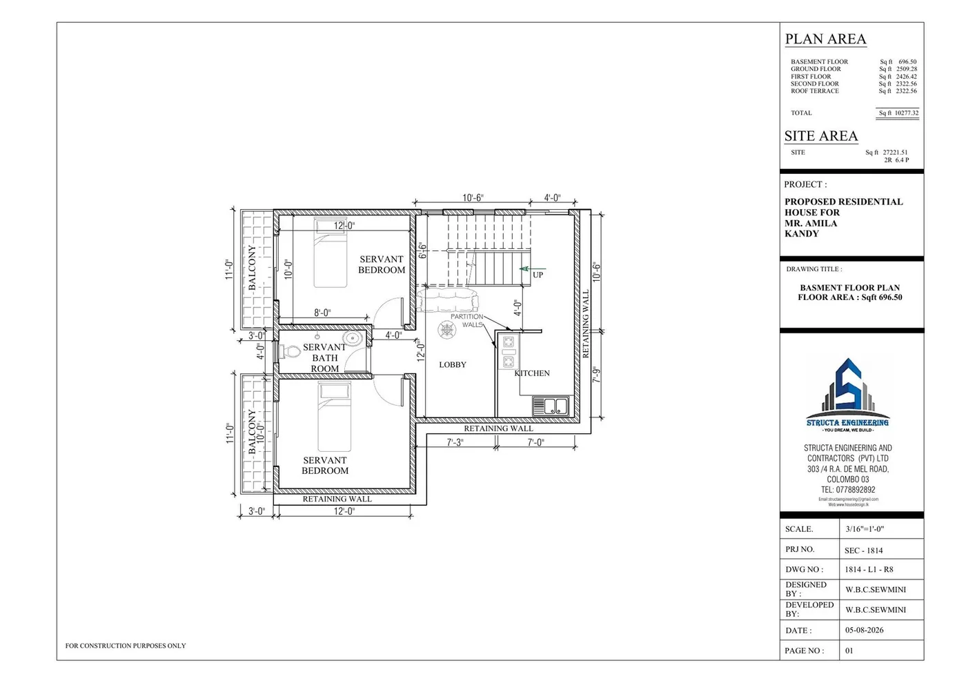
Figure 5. The basement plan: 696.50 sq ft with retaining walls annotated along three sides, and the fourth side opening onto two balconies where the ground falls away.
Look at what that plan is doing. Retaining walls are annotated along three sides. On the fourth side there are two balconies, each 11 ft by 10 ft. A basement with balconies is a contradiction on flat land and completely ordinary on a slope: three sides are buried in the hill, and the fourth looks out over ground that has dropped away below.
Inside that 696.50 sq ft are two staff bedrooms, a bathroom, a kitchen and a lobby, with a stair rising into the main house. This is habitable accommodation with daylight and cross ventilation, not a store or a cellar.
Where the saving actually comes from
Four things happen at once when the cut becomes a basement.
The retaining wall does two jobs for one cost. On a slope you are building a retaining structure whether or not you build a basement. Here that same wall is also the enclosure of an occupied room, so its cost is shared between earth retention and floor area.
The excavated volume becomes floor area rather than spoil. Every cubic metre you dig out on a hillside has to go somewhere, and disposal from a constrained hill site is not cheap. Here the void that the excavation creates is the room.
Imported fill is avoided. The building follows the ground instead of the ground being reshaped to follow the building.
The foundations bear on undisturbed ground, not on engineered fill – usually a simpler and shallower foundation design.
To put orders of magnitude on that, a documented Structa Bill of Quantities from May 2026 on a different, flat site recorded earth excavation at LKR 3,000 per m³, soil filling at LKR 4,000 per m³, soil compaction at LKR 150 per m², rubble and ABC filling at LKR 8,500 per m³ and random rubble masonry in 1:5 mortar at LKR 30,000 per m³. Earthworks on a hillside are measured in hundreds of cubic metres, so decisions taken on a section drawing move millions of rupees.
One caution from that same BOQ that applies with particular force in Kandy: its excavation item is expressly for any material met with except rock requiring blasting. Hill country sites frequently hit rock at shallow depth, and rock excavation is a separate and much larger cost. That is a risk to identify with trial pits before a floor level is fixed, not a surprise to discover once the machine is on site.
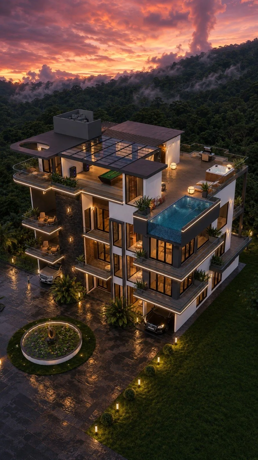
Figure 6. Seen from the lower approach, the stepped section reads clearly: the mass rises from the lower ground while the upper terraces sit level with the hillside behind.
The house, level by level
Beyond the earthworks logic, the planning is doing something specific to a hill site: it distributes the house vertically to chase the view, rather than spreading it horizontally as a comparable home on flat Colombo land would.
Ground floor – 2,509.28 sq ft
The arrival level. Two covered car parks, a verandah, a TV lobby, and a living space over 32 ft wide that runs double height into the floor above. Behind it, a dining area, a kitchen with a separate pantry and island, and a store room. A guest bedroom with its own bathroom sits at this level. A curved main stair and a lift serve the floors above.
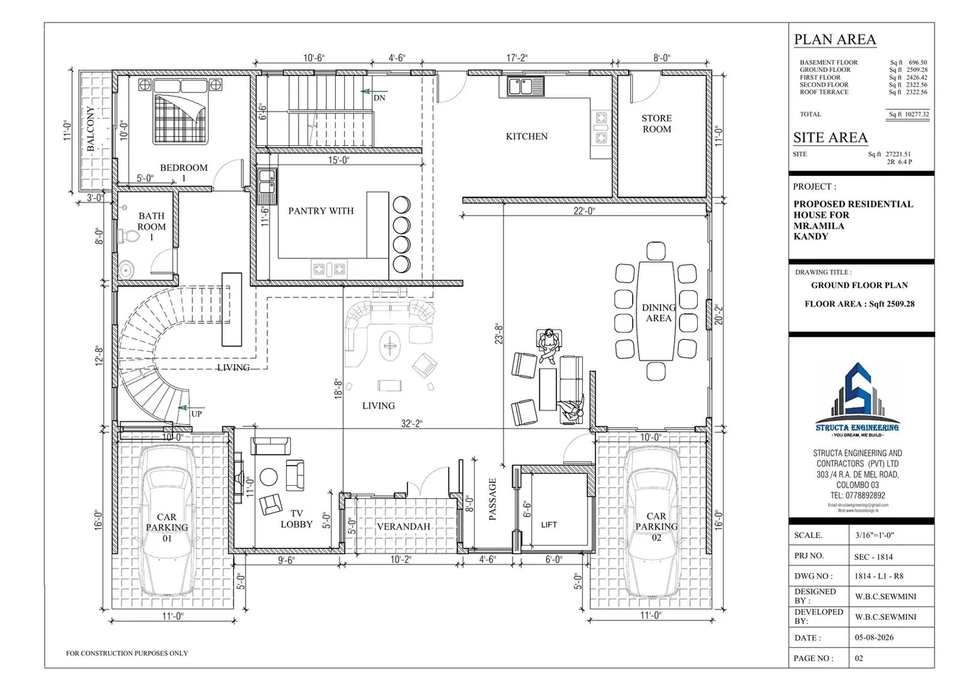
Figure 7. Ground floor plan: two car parks, verandah, double-height living, dining, kitchen with pantry, store, guest bedroom and lift.
First floor – 2,426.42 sq ft
Three bedrooms, each with a bathroom, arranged off a lobby and a TV lobby. The voids over the living area and TV lobby below are annotated on this plan, and a louvered wall appears on the terrace side. Terraces and balconies wrap much of the floor.
That combination – a double-height void, a louvered wall and generous cross-ventilated terraces – is doing real environmental work in a hill climate. Warm air rises through the void and out at high level, while the louvers admit air without admitting driven rain. Kandy is humid and wet, and a house that cannot move air quietly through itself is a house that grows mould.
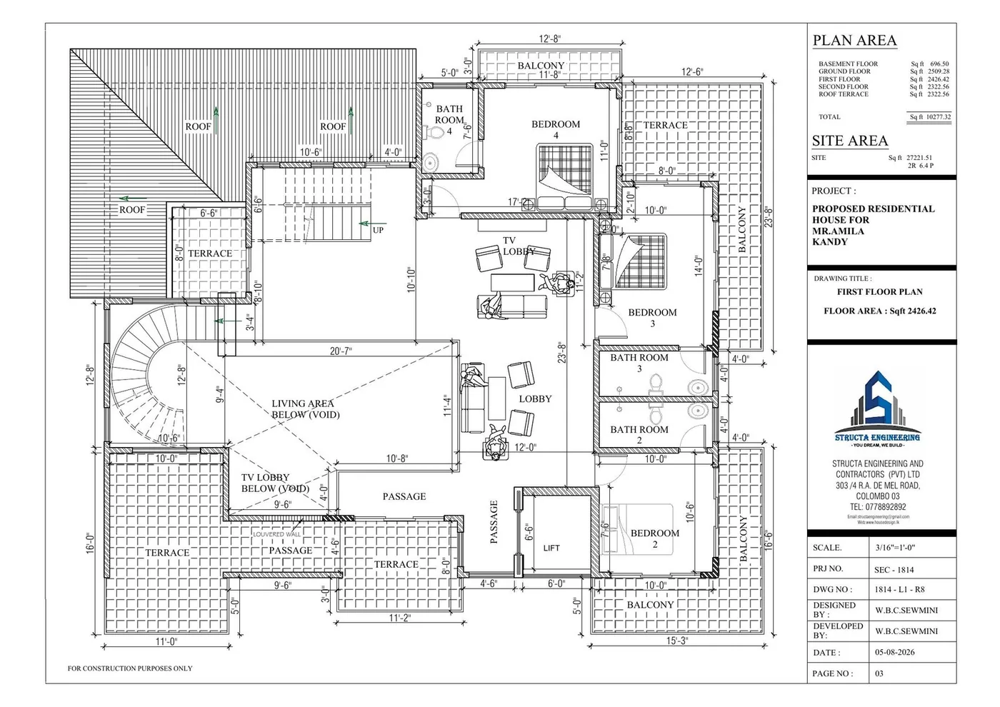
Figure 8. First floor plan: three en-suite bedrooms, lobby and TV lobby, voids over the living areas below, louvered wall, and wrapping terraces and balconies.
Second floor – 2,322.56 sq ft
The master level. A master bedroom with a large bathroom, a mini kitchen, a gym area, a generous lobby, and a substantial terrace. Placing the principal suite on the second floor rather than the ground is a hillside decision: this is the level with the valley view.
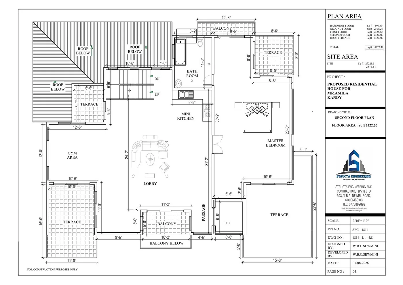
Figure 9. Second floor plan: master bedroom and bathroom, mini kitchen, gym area, lobby and a large terrace.
Roof terrace – 2,322.56 sq ft
A pool, a jacuzzi, a bar area under an upper pergola, and a further bedroom and bathroom. The lift runs to this level, which is what makes a rooftop entertaining floor genuinely usable rather than aspirational.
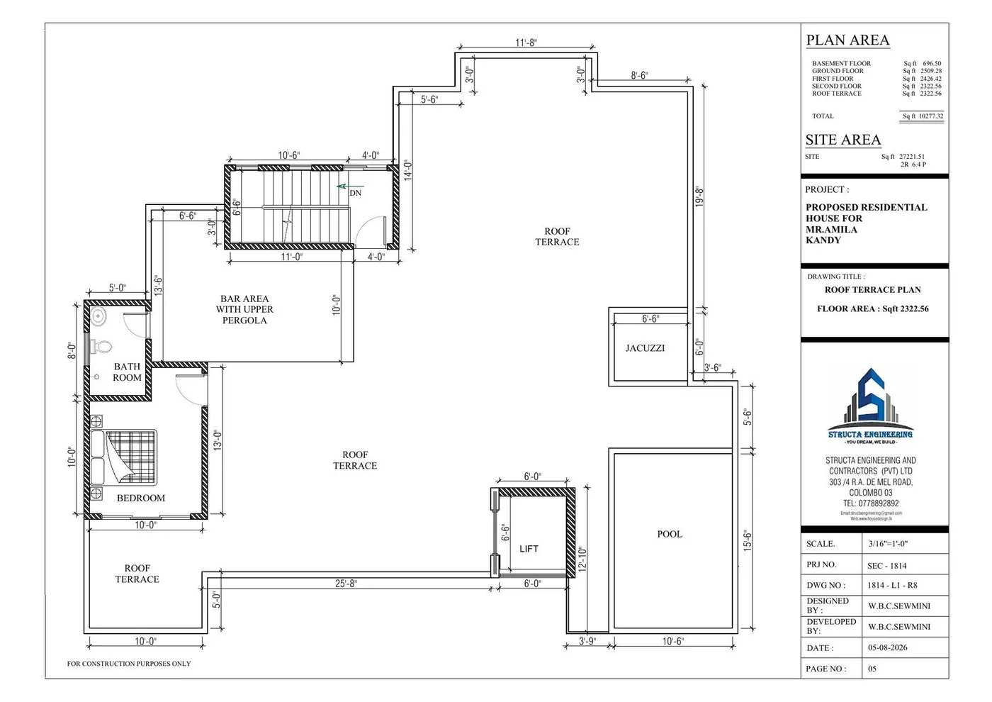
Figure 10. Roof terrace plan: pool, jacuzzi, bar area with upper pergola, bedroom and bathroom, lift and stair access.
A rooftop pool on a hillside house is not only an amenity decision. It is a structural and drainage decision, and it has to be made early: the pool’s water load, its waterproofing, and above all its overflow and backwash discharge route all need to be resolved in the structural and plumbing design rather than added later.
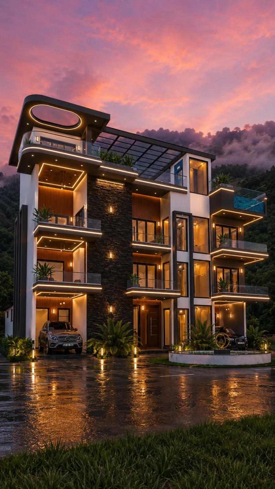
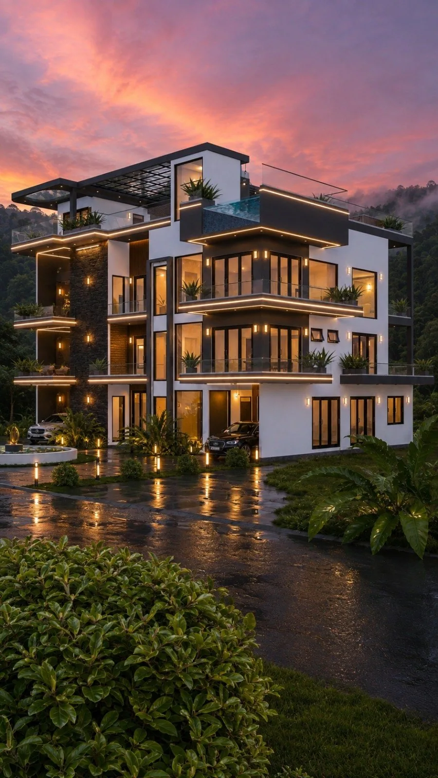
Figure 11. The elevation at dusk. Deep balcony slabs on every level give shade and rain protection, while the stone-clad circulation core anchors the composition.
What to check before designing on a Kandy site
This is the list we work through on hill country projects. Much of it does not appear on a Colombo checklist at all.
Survey and levels
Commission a contour plan, not just a boundary survey. Confirm the contour interval and that the datum used is stated on the drawing.
Get spot levels at every boundary marker and at every existing feature – walls, banks, slabs, gate, trees.
Record the level of the access road at the point of entry. The difference between road level and your intended floor level sets your driveway gradient.
Check the driveway gradient is drivable in the wet, loaded and reversing. A gradient that works on paper can be unusable for a low car after rain.
Treat live fences and stakes as provisional boundaries. Ask for permanent markers before construction sets out.
Ground, slope and landslide risk
Establish whether NBRO clearance is required. Kandy District includes landslide-prone areas, and clearance requirements are commonly triggered both by slope and by the presence of a basement or significant cut.
Commission trial pits or a soil investigation to find the depth to rock and the character of the residual soil.
Price rock excavation as a separate risk. Standard BOQ excavation rates exclude rock requiring blasting.
Have every retaining wall designed by a structural engineer for the actual retained height, the surcharge from anything above it, and saturated soil conditions – not copied from another project.
Walk the site for existing distress: tension cracks, tilted trees, bulging walls, seepage points. All are information.
Check what your uphill neighbour is doing or may do. A cut or a discharge above you becomes your problem.
Drainage – the item most often underestimated
On flat land, drainage is a plumbing exercise. On a slope it is a site engineering exercise, and it is the single most common cause of expensive failure in hill country houses.
Identify every natural watercourse and drainage line crossing the plot. The contour plan for this site records one running diagonally through it. You do not build across a drainage path; you design for it.
Work out the upslope catchment. Water arriving from land above you is not your rainfall, but it becomes your problem the moment it reaches your cut.
Install cut-off or interceptor drains along the uphill boundary, to catch surface water before it reaches the house rather than after.
Provide subsoil drainage behind every retaining wall: granular backfill, filter fabric and weep holes. Hydrostatic pressure from a blocked or omitted drain is the classic reason hill country retaining walls fail, and the wall almost never fails in dry weather.
Identify a legal, permanent discharge point for storm water before you design the drainage. You cannot concentrate flow onto a neighbour’s land, onto a cut slope or into an unprepared bank.
Size gutters and downpipes for hill country rainfall, not Colombo rainfall, and pipe roof water to the outfall rather than spilling it onto the ground near foundations or fill.
Maintain the existing earth drains along the road frontage recorded on the survey plan. Building over them transfers a problem onto the road and onto your neighbours.
Drain the driveway itself with cross-falls and channel grates, or it becomes the fastest watercourse on the site.
Design the discharge route for pool overflow, backwash and terrace drainage. A rooftop pool needs this resolved in the drawings.
Be careful with soakage pits on slopes. Soakage in sloping ground can resurface downhill, and separation distances from wells still apply – Structa drawings note figures in the range of 50 to 60 ft from all wells, and the applicable council requirement should be confirmed.
Statutory and services
Confirm the approving authority: a Pradeshiya Sabha such as Kundasale, or the Kandy Municipal Council, and whether the area is a declared UDA area.
Obtain the street line or building line certificate for the frontage, and note its expiry.
Confirm the survey plan carries the local authority approval stamp. The plan for this site carries a 2019 Pradeshiya Sabha reference.
Commission structural drawings, calculations and the structural engineer’s certificate. With a basement and multiple retaining walls, this is not optional.
Confirm NWSDB mains availability and the pressure available at your elevation, and design tank position and pumping accordingly.
Confirm the CEB supply point and pole positions relative to your access.
Check tree cover and removal permissions. Named mature trees appear on both plans for this site, and root zones interact with retaining structures.
Specify for damp, mist and condensation: waterproofing, ventilation and mould-resistant finishes.
Check construction access early. If a concrete truck cannot reach the platform, you are pumping, and that changes the price.
What a home of this scale costs to document
Structa house-design packages start at LKR 150,000 for Silver, LKR 200,000 for Gold and LKR 400,000 for Platinum, valid up to 2,000 sq ft, with an additional LKR 75 per sq ft above that and the final figure confirmed after a site visit. A home of 10,277.32 sq ft therefore sits well above the starting figures, and a project of this complexity is scoped individually.
A hillside project of this kind should be documented at Platinum level for a specific reason: on a stepped section, the drawings that Silver and Gold omit – setting out, tile layouts, bathroom details, the door and window schedule – are the drawings that resolve level changes. On flat ground a missing setting-out plan is an inconvenience. On a site with a 15 metre fall and four floor levels tied to retaining walls, it is a source of compounding error.
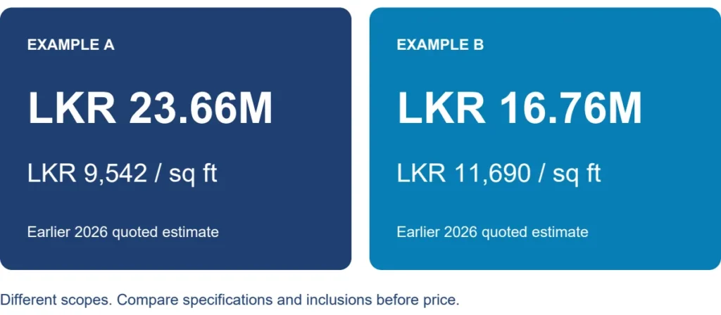
Construction cost is separate and site-specific. For context on how a Structa BOQ is built up and what per-square-foot figures do and do not tell you, our 2026 construction cost guide sets out two documented projects at LKR 9,541.98 and LKR 12,930 per sq ft, and explains why the difference is largely ground conditions rather than finish standard.
Frequently asked questions
Do I need a contour plan to build a house in Kandy?
For any sloping site, yes. A contour plan records the shape of the ground surface, which a boundary survey does not. Without it you cannot reliably set finished floor levels, calculate cut and fill volumes, design retaining walls, work out a drivable driveway gradient or plan surface water drainage. The plan for this project is at 1:500 with 1 metre contour intervals and levels referred to an assumed datum of 100 metres at the road.
What is the difference between a survey plan and a contour plan?
A survey plan establishes the legal extent, shape, boundaries and access of the land in plan view, and is prepared by a Registered Licensed Surveyor for use in your building application. A contour plan adds the third dimension: heights across the site, shown as contour lines and spot levels. They are separate drawings, often by separate surveyors, and on a hill site you need both.
Why do Colombo projects often not need a contour plan?
Because the difficulty in Colombo is usually vertical bearing rather than surface shape. The western coastal belt is low and flat, frequently on filled or marshy ground, so the investigation that cannot be skipped there is geotechnical – soil bearing capacity, ground improvement and flood level. In the central hills the ground is often competent but steep, so the survey that cannot be skipped is topographic.
Does a basement make a house more expensive to build in Kandy?
Not necessarily, and on a slope it can be the cheaper option. On sloping land you are already paying for earthworks and retaining structures. A basement lets the retaining wall you must build anyway also serve as the wall of an occupied room, and turns excavated volume into floor area instead of spoil to be carted away. In this project a 696.50 sq ft basement is created that way, with retaining walls on three sides and balconies on the fourth where the ground falls away.
Do I need NBRO clearance to build in Kandy?
Kandy District includes landslide-prone areas, and clearance from the National Building Research Organisation is commonly required in those areas. It is also frequently triggered where a basement or a significant cut is proposed, independently of location. Establish the position for your specific site early, because the finding can change the design.
What is the most common mistake on hill country house projects?
Underestimating drainage. On flat land drainage is a plumbing item; on a slope it is site engineering. The recurring failures are omitted subsoil drainage behind retaining walls, no interceptor drain along the uphill boundary, and no legally secured discharge point for storm water. Retaining walls in the hill country almost never fail in dry weather.
How large a house can I build on 100 perches in Kandy?
It depends on the setbacks confirmed by your street line certificate, the coverage and height permitted by the applicable authority, and on the slope. This project achieves 10,277.32 sq ft of total plan area on 27,221.51 sq ft of land at about 9.2% ground floor coverage, by building four levels plus a roof terrace rather than spreading out. On a slope, going up is often cheaper than going wide.
Should the master bedroom be on the ground floor or upstairs in a hill country house?
On a hillside site the view is usually the reason for building there, and the view improves with height. In this design the principal suite is on the second floor and the pool and bar terrace are above it, with a lift serving four levels so that the upper floors are genuinely usable. On flat land the same reasoning does not apply and a ground floor principal suite is often the better answer.
How long does a hillside house design take?
Longer than an equivalent house on flat land, because the design has to be tested against the ground. The layout for this project is at revision R8. The variable is not drawing speed but how many iterations it takes to reconcile floor levels, retaining heights, access gradient and drainage.
Can Structa design a house in Kandy from Colombo?
Yes. The studio is in Colombo and projects across the Central Province are handled from there, beginning with a site visit. What cannot be done remotely is the survey work: the contour plan and the boundary survey must be prepared on site by licensed surveyors, and on a hill site the design cannot start without them.
Hill country pre-design checklist
Boundary survey plan by a Registered Licensed Surveyor, with local authority approval stamp.
Contour plan with a stated datum and contour interval.
Spot levels at the road entry point and all boundary markers.
Trial pits or soil investigation, including depth to rock.
NBRO position established for the site.
Identification of all watercourses and the upslope catchment.
A secured, legal storm water discharge point.
Street line or building line certificate, in date at submission.
Confirmation of the approving authority and whether the area is UDA-declared.
Structural design and certificate covering the basement and all retaining walls.
NWSDB and CEB availability confirmed at your elevation and access point.
Construction access assessed for concrete delivery.
Sources, creation date and disclaimer
This guide was prepared on 10 August 2026 from project documents held by Structa Engineering and Contractors (Pvt) Ltd:
Layout drawing set SEC-1814, revision R8, dated 5 August 2026, comprising basement, ground, first, second floor and roof terrace plans at 3/16" = 1′-0", recording a total plan area of 10,277.32 sq ft on a site of 27,221.51 sq ft.
Survey plan, Plan No. 2266, Extract of Lot 2, prepared 5 March 2019 by a Licensed Surveyor and Leveller, resurveyed from Plan No. 3390A dated 2 August 2005, situated at Kengalla Village, Udagampaha Korale of Pata Dumbara, Kandy District, Central Province, bearing a Pradeshiya Sabha approval reference of July 2019.
Contour plan, Plan No. 4152, contour plan of Lot 2 in Plan No. 2266, scale 1:500, contour interval 1 metre, levels referred to an assumed datum of 100 metres at the road.
Architectural visualisations of the proposed residence.
Unit rates quoted for context are from a separate documented Structa Bill of Quantities dated 23 May 2026 for a project on a different, flat site.
Owner, surveyor and consultant names and contact details have been removed from published figures. Levels quoted are read from the contour plan and are approximate; the plan itself governs.
Approval requirements, clearance requirements and fee schedules differ between authorities and change over time. Slope stability, retaining structure design, foundation design and drainage design are project-specific engineering matters that must be resolved for your own site by appropriately qualified professionals. This guide is general information based on one documented project and is not advice on your land, and not a quotation.
Next step
If you are considering building in Kandy, Kundasale, Digana, Teldeniya, Kengalla, Balagolla, Peradeniya, Katugastota or anywhere in the central hills, the first useful conversation is about your land rather than your house. Send the survey plan and, if you have one, the contour plan, and we will tell you what the site will allow and what it will cost to make it buildable.
Useful next pages: explore Structa house designs; compare design packages; read how much it costs to build a house in Sri Lanka in 2026; understand building approval in Sri Lanka; see our structural engineering service; or contact the studio for a site visit.
Kandy hillside luxury house design FAQ
What makes a luxury house design in Kandy different?
Kandy luxury homes often need to respond to slope, views, rainfall, access, retaining requirements, privacy, roof form, climate and structural complexity instead of copying a flat-land plan.
Can a hillside residence be built into a slope?
Yes, but the design must coordinate levels, foundations, retaining strategy, drainage, access, structural spans and construction sequencing before work begins.
What should be checked before designing a hillside house in Kandy?
Check the survey levels, road access, soil and rock conditions, stormwater flow, retaining needs, view direction, sunlight, privacy, local authority requirements and build logistics.
Why does a luxury residence need coordinated drawings?
Large hillside homes need architecture, structure, MEP, drainage, openings, BOQ and approval documentation to work as one system. Otherwise site changes can become expensive.
Next step
If you are planning a house in Sri Lanka, start with a proper site visit, concept design, structural approach and BOQ before committing to construction. Structa can coordinate the architectural drawings, structural drawings, interior direction, MEP drawings and documentation as one buildable package.
Useful next pages: compare Structa design packages, explore our architectural and engineering services, understand the house design process, browse free house design ideas, or contact Structa for a site visit.
Use this guide as general information
Site conditions, authority requirements and construction decisions vary by project. Confirm project-specific architectural and engineering matters with appropriately qualified professionals before relying on them for construction.